Hoffman Notch Wilderness
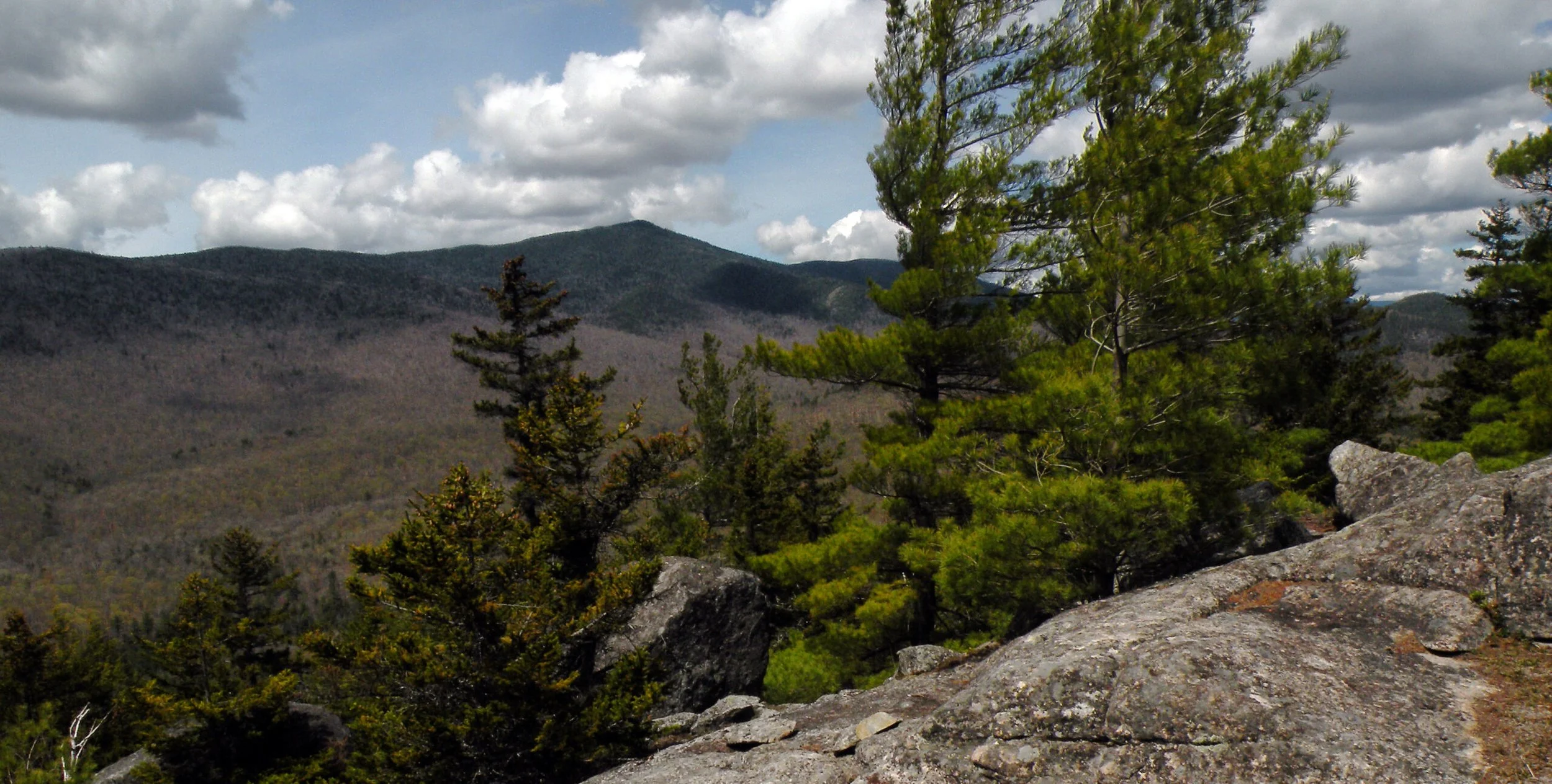
The Hoffman Notch Wilderness is a perfect example of how true wildness can sometimes be hidden in plain sight.
Hoffman Notch Wilderness
at a Glance
Size: 38,234 acres
First Designated: 1972
Unit Management Plan Status: Completed in 2012
Special Regulations: None; standard Forest Preserve regulations are in effect
Although it directly abuts an Interstate highway, and although its size is rather middling, solitude and natural beauty abound. In other words, Hoffman Notch is Adirondack wilderness at its best – despite its accessibility.
Many people have seen this wilderness, whether they are aware of it or not – but few can say they know the landscape on an intimate basis. Ever since I-87 (known as the Adirondack Northway) opened in 1967, the Blue Ridge Range has been adorning roadside vistas for thousands of drivers every day. It is a place that seems so close to “civilization” that it can hardly be considered remote, by any standard. Indeed, several of its most popular destinations are barely a mile from the starting point, and the area’s most iconic scenery can be consumed with minimal effort.
But as one penetrates a little deeper, a rugged and lightly-traveled landscape reveals itself. Traffic sounds fade away quickly, and even the marked hiking trails become faint trackways. Trees of the deep forest grow to impressive dimensions, and streams tumble noisily through unseen gorges.
One might say this is the Rodney Dangerfield of wilderness areas, never getting the respect it deserves — a trend that began when the original planners of the Adirondack Park were considering the location of its boundaries. Depending on which map one views, Hoffman Notch was either bisected by the proposed “Blue Line” or placed right on its edge. When the state officially established the Adirondack Park in 1892, the approved boundary cut a tenuous line between Schroon Lake and the foothills of the Blue Ridge Range.
Some seven decades later, the area was overlooked entirely by the Joint Legislative Committee on Natural Resources, which was the first state entity to consider protecting portions of the Adirondack Forest Preserve as wilderness. While the committee did publish a map in 1965 listing twelve potential wilderness areas, Hoffman Notch was not among them. Perhaps it was because snowmobile trails cut through the area, including the eponymous Hoffman Notch, thus making the area seem less worthy of protection.
A proposal to create an “Adirondack Mountains National Park” in 1967 similarly placed Hoffman Notch square against the boundary. However, things began to look better in 1970, when the Temporary Study Commission on the Future of the Adirondacks proposed the creation of a “Hoffman Notch Primitive Area” in 1970, which would’ve been a stepping stone to an eventual wilderness classification. But the staff of the newly-formed Adirondack Park Agency skipped this intermediary step in 1972 and designated most of the area as wilderness.
Although it is now fully protected, the tendency to overlook this area continues today, even among wilderness enthusiasts. Location may be partly to blame. Sandwiched as it is between two of the most popular areas in the Adirondacks – the High Peaks and Pharaoh Lake wildernesses – Hoffman Notch seems pretty lackluster in direct comparison. While it does contain a few notable peaks, there is nothing quite on the scale of Mount Marcy, and the area’s ponds are too few and scattered to tempt people away from those gracing the ever-popular Pharaoh Lake Wilderness on the opposite side of Schroon Lake.
Nevertheless, this is an area that does bear close scrutiny. There is nothing but joy to be found in exploring its various corners, which display subtle variations along its east-west axis. The upland forests in the western expanse display a clear affinity for the central Adirondack plateau, to which they naturally belong. The eastern slopes, by contrast, are delightful in their playful experiments with Thuja occidentalis, the eastern white cedar, a tree that is not distributed evenly across the Adirondack Park. Underlying everything is the area’s anorthosite bedrock, which technically makes this region an extension of the High Peaks – even if its highest peaks fall 300 feet shy of “peak bagging” status.
Therefore this is a remarkably wild and diverse landscape, despite its relative accessibility and compact size. Hoffman Notch may not be the biggest wilderness or the most popular, but it never fails to impress those few people who do come to tease out its secrets.
Please click through the tabs below to learn more about the Hoffman Notch Wilderness.

-
Perhaps the most distinctive feature of the Hoffman Notch Wilderness is its topography, with multiple north-south mountain ranges indented by parallel valleys. This rigid pattern is unlike the randomness of most other areas in the park, making it seem more like a traditional mountain range – even if this pattern is probably just a byproduct of fault lines in the bedrock, just like everywhere else.
The largest grouping of mountains here is the Blue Ridge Range – an uninspired name for a chain that nevertheless forms a stunning backdrop to several communities along the Schroon River. Its apex is Hoffman Mountain, which at 3693 feet in elevation makes it much more than just a foothill of the High Peaks. Its graceful, pyramid-like profile enchanted the Hudson River School painter Thomas Cole, who reimagined the mountain as a place of sublimity when he painted his 1838 masterpiece View of Schroon Mountain, Essex County, New York, After a Storm (The Cleveland Museum of Art, Hinman B. Hurlbut Collection). It also inspired the local towns to propose a major ski development here in the 1960s, but this idea was happily defeated by the state’s voters during a 1967 referendum.
No trails lead to the mountain, and its summit is notorious for its thick forest growth; only the most diehard of peak-baggers subject themselves to its hardships. But Hoffman is orbited by its own cluster of foothills, some of which atone for the harshness of the main summit: Severance Hill is one of the mildest climbs anywhere, Jones Hill is steep and narrow, and the various Peaked Hills are bushwhacking delights.
Within the wilderness boundaries there are at least three major fault valleys dividing the mountain ranges, with Hoffman Notch being the most distinctive. This “notch” is far less rugged than the various mountain passes that indent the High Peaks to the north, with more than enough width for scattered beaver flows. Forest quality is quite good here at the heart of the wilderness, and the hike from Loch Muller to Blue Ridge Road leads from recovered farmland to deep woods and back to managed timberlands in quick succession.
The area does feature several ponds, all of them scenic in their way, but most are found near the outer fringes of the area. Marion Pond is the highest, and the closest to being a true trout pond. The rest are low-elevation bodies of water, and except for Big Marsh none of those are located more than a mile from a road.
This wilderness is rich with streams, but the designated boundaries fall short of including any of the large rivers in the immediate vicinity – except for the briefest section of the Boreas River in the far northwestern corner. Thus one’s attention is drawn to features such as Durgin Brook, Platt Brook, Trout Brook, and Seventeenth Brook, among others. Those in the central and western valleys are typically tannic, just like practically every other stream in the central Adirondacks. However, the brooks that tumble down the eastern slopes are clear mountain streams, each of them slipping unseen through tunnels underneath the Northway.
Despite the relatively compact size of the Hoffman Notch Wilderness, its forests display a remarkable amount of diversity. These begin with the pine-heavy reforestation areas near Bailey and Big ponds, which in the nineteenth century were extensions of human settlement. Much of the northwestern corner of the wilderness is blocked by a thick growth of spruce, pine, and fir, seeming to defy the very notion of human access. The mid-slopes exhibit the typical stands of northern hardwoods mixed with red spruce and eastern hemlock that are common throughout the Adirondacks. And if one persists up to the highest summits, it will be spruce and balsam fir getting in the way.
These patterns fall apart on the eastern slopes, where eastern white cedar – known to gardeners as arborvitae or “the tree of life” – comes into play. Cedar groves are everywhere, and like a reactive chemical element they interact with their neighbors to form new and unexpected forest combinations. For instance, they grow beside white pine along the shore of North Pond, with balsam fir along the lower reaches of Platt Brook, and with hemlocks at Seventeenth Brook’s narrow gorge — each combination offering its own aesthetic delights. At a few select sites, cedar grows in almost pure stands.
The durability of its wood means these trees tend to linger long after they die, imparting an atmosphere of desolation to the ponds, bogs, and wetlands where fluctuating water levels have doomed entire stands of cedar.
Human habitation pushes against the wilderness boundaries along its southern edge, and the Northway permanently limits the potential for growth along the entire eastern boundary. The mountains push back at the northern frontier, though, where even today settlement is restricted to the narrow valley of The Branch. A drive along Blue Ridge Road offers several exciting glimpses of the Hoffman Notch Wilderness.
The western boundary is a different story, though. Here nothing but the Minerva Stream Trail defines what is otherwise an arbitrary line through the landscape; the forest itself extends seamlessly into a trackless section of the Vanderwhacker Mountain Wild Forest to the west.
-
The Hoffman Notch Wilderness does contain a handful of sites that reveal glimpses of the area’s human history, although those signs are comparatively few and far between. Most signs of human occupation occur near the fringes of the area, where the precise boundaries of “civilization” and “wilderness” have been in a state of flux for two centuries.
One of the easiest historic sites to find is a small clear cellar hole just a few steps beyond the parking area at the Big Pond trailhead on Hoffman Road. The trail itself was clearly once a minor road; the condition of the forest, with a plantation of pine along the first half-mile of trail, strongly suggests that this corner of the wilderness was cleared pastureland in the nineteenth century. The original name for Big Pond was Rogers Pond – and it was certainly bigger than Little Rogers Pond to the south, which today is known as Bullet Pond.
Likewise, the Dirgylot Hill area was almost certainly a large clearing – although here the process of forest regeneration is much less advanced. Amidst the non-wilderness springhouses maintained in this area, one may find a solitary grave. The original headstone bears only the initials E M, but a nearby plaque supplies a few additional details:
IN LOVING MEMORY OF
ELIZABETH
DAUGHTER OF
CHARLES AND SARAH E.
BENTON MILLER
OCTOBER 16, 1881 – JUNE 10, 1917
To the west, civilization still presses close to Bailey Pond, just as it did during the Civil War era. For many years the last resident at the end of the road in Loch Muller was A. Warren. This property became the site of the Bailey Pond Inn, and later Warren’s Inn; throughout the course of its existence the inn served as a sportsmen’s portal to the wilderness. One of the Warren proprietors had a granddaughter named Marion, which some people suppose was the inspiration for Marion Pond’s name.
A minor road sneaked its way into the woods to Bailey Pond, where a low stone dam still augments the water level to a small degree. Some amount of logging occurred on the surrounding mountainsides, all the way up to Marion Pond where a collection of abandoned saw logs can still be found at the outlet. Perhaps the prospects of hauling these logs off the mountain proved to be too daunting; the outlet stream was not large enough to float the thirteen-footers, and the faint traces of the logging road underlying today’s footpath suggest this was an incredibly steep route. Log-laden sleds probably could not make a safe descent along this route without mechanical braking systems. Or maybe the logs were just surplus timber, harvested but not actually needed.
Mechanized logging occurred at the north end of Hoffman Notch into the mid-twentieth century. Here, an unusual event occurred. The Glens Falls logging company commonly known as Finch Pruyn gifted 2426 acres at Sand Pond Mountain and Hoffman Notch Brook to the state circa 1960, invoking a provision in the state’s conservation law that probably never worked as intended. This particular statute allowed New York to take title to donated properties “for forestry purposes.” To some people, it implied a way around the strict forever-wild provisions of Article XIV, and therefore lands donated to the state (in theory) were not part of the Forest Preserve.
Although the Finch Pruyn parcel was omitted from the original wilderness boundaries, the state never conducted any forestry operations there. Indeed, all gift lands throughout the Adirondacks have always been managed as part of the Forest Preserve, regardless of the method of acquisition.
In 2001, the logging company sued the state in a bid to regain title to this land (and other similar “gift lands” elsewhere in the Adirondacks), arguing the state’s failure to log the parcel constituted a forfeiture of sorts. The courts disagreed, ruling in 2002 that no mechanism existed to return the gift lands to the original donors, and that at any rate Article XIV of the state’s constitution applied to all state-owned lands in the Adirondack Park. Therefore even the lands donated to the state for “forestry purposes” were automatically part of the Forest Preserve.
Finch Pruyn’s bid to redeem the parcel ended here, and in 2005 it was finally added to the wilderness, thus fully protecting Hoffman Notch. Despite its history, though, the once-disputed parcel is remarkably well forested. The northern trail to Hoffman Notch follows traces of an old logging road for a brief time, and the partial remains of an old skidder are difficult to miss. Otherwise, though, one would never suspect this forest had been acquired so late – or that it had been the subject of a legal dispute.
-
One of the more peculiar aspects of this wilderness is that almost all of its well-known destinations are located in peripheral areas, well away from the remote interior. This makes Hoffman Notch somewhat “inside-out” compared to most of the other protected areas in the Adirondacks, which hold their best scenic secrets deep within their boundaries. It also might partially explain why an area so accessible is so little known to the general public, aside from these few peripheral treasures.
The state-maintained trail network is somewhat limited, but adequate given the level of interest. The marked trails to Bailey Pond, Big Pond, and Severance Hill are all short and easy – and therefore well used. The longer trail past Big Marsh within Hoffman Notch is only moderately used, and the trail between Big Pond and Trout Brook sees hardly any foot traffic at all.
Most of these wilderness trails were open to snowmobiles as late as 1972, when the area was first designated as wilderness. Back then the trail network was slightly more robust, with additional routes that have been all but forgotten: one to the west of Washburn Ridge, and another that supposedly curved around the foot of the Peaked Hills to Dirgylot Hill. Even older yet, maps from the nineteenth century show quite clearly that the trails to Bailey and Big ponds were originally roads – a fact which probably won’t surprise many of the people who hike these routes today.
Limited though it may be, the Hoffman Notch Wilderness trail system will soon expand. A new trail over Jones Hill is already partly constructed (as of 2021); this will eventually create a through-route from Big Pond to Dirgylot Hill, by way of North Pond and Platt Brook. Jones Hill is likely the place from which Thomas Cole sketched Hoffman Mountain in 1838, and its view remains first-rate.
And this new trail will likely become part of the North Country National Scenic Trail, which is slated to pass through the southern part of the wilderness.
When unofficial trails are considered as well, the area’s recreational possibilities become more robust. Such routes can be found south of Hayes Mountain, as well as both east and west of Marion Pond. An entire network of old roads and unmarked footpaths branches westward from Dirgylot Hill.
Because I-87 defines so much of the area’s eastern boundary, the only access from this side is through a series of pedestrian tunnels underneath the highway. There are four such tunnels altogether, although only the ones at Severance and Dirgylot hills have access routes maintained by the state. Despite the presence of a busy interstate highway, solitude and seclusion are delightfully easy to find here.
Not only are there no lean-tos in the Hoffman Notch Wilderness, DEC has not designated any campsites either. Only the sites at Big and Marion ponds seem to enjoy quasi-official status; others, such as a traditional campsite at Bailey Pond, may be added in the near future, but established campsites are surprisingly few and far between.
Rock and ice climbers have discovered a few of the area’s cliffs, and each of the major ponds supports a fishery of one kind or another. But so much of this wilderness remains unknown that the possibility for a solitary experience is high, in any season. This is much more than anyone might expect from a mid-sized wilderness that abuts a busy town and is bounded by a major four-lane highway!
But if there is one thing that all people in pursuit of wilderness recreation should know, it is this: the Hoffman Notch Wilderness does support a population of deer ticks. These potentially disease-bearing arachnids can be found throughout the low-lying portions of the wilderness, including trailheads and campsites.
-
The Hoffman Notch Wilderness is perhaps less “threatened” than it is poorly understood. There are no looming disasters to thwart, no lingering controversies, nor throngs of humanity threatening to displace its wildlife. Nevertheless, each area of the Adirondack Park has its items of concern, and this one is no different.
Dirgylot Hill Springhouses
A parcel acquired by the state circa 1980 in the eastern portion of the wilderness provided a strategic point of public access to all of the foothills otherwise cut off by the Northway. With Dirgylot Hill as the key topographic feature, this addition featured an array of trail-worthy logging roads – and most importantly, access via one of the pedestrian tunnels under the highway.
However, the tract appears to be encumbered by a set of six privately maintained springhouses. Presumably these are facilities with deeded rights of way, although state documents are extremely unclear about this; currently only one private right of way is recognized, leading to a tiny inholding that encompasses the two northern sites. But in actuality, private motorized access occurs at all six sites.
If there is deeded landowner access to these springhouses, then the solution is to make a slight boundary adjustment to exclude this area from the wilderness. All six sites are clustered in a relatively small area in the extreme periphery of the wilderness not far from I-87, so reclassification of this area would not be significant. But if no deeded rights exist, then these springhouses are an Article XIV issue – an illegal violation of the “forever wild” clause of the state’s constitution.
Wilderness Access
Access to the Hoffman Notch Wilderness is good, but several factors conspire to limit public ingress to a handful of sites.
The most obvious barrier is I-87 itself, which bounds the entire easternmost frontage of the wilderness from Exit 28 to Exit 29. Wilderness access is possible only at four pedestrian tunnels scattered throughout this section, but of those only two are currently maintained: Severance Hill and Dirgylot Hill. Two other tunnels exist, but the state is choosing not to maintain them. The northernmost tunnel would require building a substantial bridge over a fish weir on the Schroon River near North Hudson.
Elsewhere, private land and other terrain constraints limit access to the northern and southern boundaries, where the existing trailheads at Hoffman Notch, Big Pond, and Loch Muller are effectively the only legal points of entry. To the northwest, a proposed trail to Durgin Brook may open an additional option. Otherwise, the Hoffman Notch Wilderness is lacking in places where one may simply park along a road and enter the woods at a random location.
Western Boundary
The one major exception to the limited number of access points is the area’s western boundary, which is defined by the routes of two historical roadways. Here, the Hoffman Notch Wilderness abuts the Vanderwhacker Mountain Wild Forest in an area where a reexamination of the boundary seems warranted.
Most of this boundary is defined by the trail along Minerva Stream, a former wagon road that is now technically a snowmobile trail. Its main use, however, is by the owners of a tiny, three-cabin inholding near Mud Pond, who use ATVs to reach their property. Otherwise, an unbridged crossing of the Boreas River at Lester Dam makes through-use by snowmobiles all but impossible, and the northern portion of the trail is scarcely used by anyone.
The inholding aside, this part of the wilderness boundary seems somewhat arbitrary – leaving room for a motorized trail that no one uses. To the west, there is a significant amount of motorless acreage stretching nearly to NY 28N that seems eligible for a wilderness reclassification. This area includes Green Mountain and a section of the Boreas River.
Recreational Features
Compared to the busy High Peaks Wilderness to the north and the equally busy Pharaoh Lake Wilderness to the east, it is refreshing to find a wilderness-caliber landscape between these two areas that does not share their long menu of management issues. On the other hand, Hoffman Notch has suffered from a touch of neglect – some of which may be alleviated soon.
The 2012 unit management plan for this area listed several proposed projects, from trail construction to parking lot improvements, some of which are only now (2021) getting started. For instance, the important Loch Muller trailhead suffers from a lack of good parking and a lousy access driveway, and the old roads that now serve as the trails to Bailey and Big ponds are both too muddy to be the wheelchair-friendly, universally-accessible paths envisioned by the management plan. Additionally, several bridges on the trail through Hoffman Notch were severely damaged in a 2019 storm and have not been replaced.
On the other hand, the Jones Hill trail is currently in construction, and this will greatly enhance the area’s recreational opportunities. If DEC builds the proposed lean-to at Platt Brook, it will be the only such structure in the area.
In regards to camping, the area currently suffers from a lack of legal campsites. DEC recognizes no designated campsites anywhere within the Hoffman Notch Wilderness, although two sites at Big Pond and one at Marion Pond appear to be tolerated. Camping occurs at a prominent site at Bailey Pond, but don’t be surprised if rangers remove the evidence from time to time.
If the North Country National Scenic Trail (NCNST) is to be routed through the southern portion of the wilderness, then this campsite policy will need to be reconsidered. The NCNST will be a long-distance hiking trail running west-to-east across the Adirondack Park, and this implies backpacking. Good, durable campsites will need to exist at intervals all along this trail, and the current inventory seems inadequate to meet this future need.
-
The following links leave the AWA website and take you to various pages on the Department of Environmental Conservation (DEC) website with more information on the Hoffman Notch Wilderness.
Hoffman Notch Wilderness Information Page. Learn important contact information and peruse a list of facilities.
Backcountry Information for the East Central Adirondacks. Trail conditions updated weekly for the Hoffman Notch Wilderness and neighboring areas.
Hoffman Notch Wilderness Unit Management Plan (2012). Download DEC’s official management plan, approved in 2012.
State Land Regulations. Review the complete list of DEC regulations.
All photos © Bill Ingersoll. Site visitors are permitted to download an unlimited number of images from our website for personal, educational, scientific, or professional use only, with attribution. Commercial use and further distribution of images is prohibited without express written permission.
Maps of the Hoffman Notch Wilderness and the Surrounding Area
At left is the current DEC map of the wilderness and its facilities. The remaining maps show the evolution of the area from 1879 through 1954: lakeside hotels coming and going, and the roads that faded into faint trails. Click maps to enlarge.
Hoffman Notch Wilderness Map
1897 Schroon Lake USGS Quad
1953 Schroon Lake USGS Quad
Hoffman Notch snowmobile trails (1972)
Hoffman Notch Wilderness Image Gallery