Little Moose Wilderness
The Little Moose Wilderness is an inscrutable little area, cut off from most public access for half the year and not attracting much attention to itself for the other half.
Little Moose Wilderness
at a Glance
Size: 12,201 acres
First Designated: 2010
Unit Management Plan Status: No management plan has been completed for this area
Special Regulations: None; standard Forest Preserve regulations are in effect
Nearly all of it is mountainous, with the exception of the South Branch Moose River bottomlands that happen to fall within its boundaries. It must certainly be the most wilderness-like wilderness in the Adirondacks, because so few people know anything about it, let alone make the effort to visit it.
Its existence is owed to a compromise struck between the state’s Department of Environmental Conservation (DEC) and Adirondack Park Agency (APA) in 2010, at the time the two agencies were finalizing a management plan for the Moose River Plains. At stake were the numerous drive-in camping sites strung along the Moose River Plains road network; too numerous and densely spaced for the original Wild Forest designation, the choices were to either eliminate dozens of popular campsites or to reclassify the lands to something more suitable.
DEC and APA selected the latter option, applying the Intensive Use classification to the road network and its attendant campsites. To offset this action, they chose to upgrade the 12,000-acre Little Moose area from Wild Forest to Wilderness.
Although this is now an officially designated and protected wilderness, it is virtually indistinguishable from either the Moose River Plains to the north or the West Canada Lake Wilderness to the south. By all rights, this area should have been added to the existing West Canada region, to which it is entirely contiguous. Instead, the state planners left open an option to extend a bike trail between these areas, and thus the Little Moose and West Canada Lake areas are separated by a non-wilderness corridor that almost no one uses.
Please click through the tabs below to learn more about the Little Moose Wilderness.

-
The Little Moose Wilderness consists of a sprawling, double-summited mountain isolated from its neighbors by deep valleys on all sides. It is not so much known as it is seen from a distance; the mountains do attract a small number of climbers, but most people know the area as a backdrop to something else.
Indeed, the area would be deserving of wilderness status even if it were not so isolated. The high-elevation terrain is very rugged, and the forests are thick. The highest point is Little Moose Mountain at 3634 feet in elevation, which along with its conjoined twin Manbury Mountain forms the primary feature of this wilderness. The State Land Master Plan identifies this terrain as potential Bicknell’s thrush habitat, although it is doubtful anyone has made the effort to verify this.
Perhaps the next most distinguishing feature is Sly Pond, which at 2872 feet is among the highest ponds in the Adirondack Park. It occupies a perch on the mountain plateau a short distance to the west of Little Moose Mountain, and well within sight of it. The boggy shoreline makes Sly a challenging place to explore.
Other key features include the short sections of Otter Brook and the South Branch Moose River that flow within the wilderness boundaries.
Forest quality ranges from maturing second-growth to vast expanses of montane spruce-balsam. Most of the wilderness was purchased in a single transaction from Gould Paper Co. in 1963, and past logging activities have certainly left their mark. Still, enough time has passed there is no doubt this little-known, little-used area exhibits high wilderness attributes.
-
On the one hand, this has always been a remote area far from any center of human population. On the other hand, signs of human activity can be found throughout the Little Moose Wilderness.
Old maps show the original roads that led into the Moose River Plains from the Cedar River valley passed through this area, grazing the north end of Little Moose Lake and following the course of the South Branch Moose River. A version of this road can still be found, and for a time it was managed as the Butter Brook snowmobile trail, but it is now abandoned and slowly filling in with new forest growth.
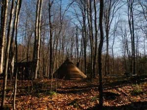
The closest thing to a settlement in this area was Kenwells, located near Otter Brook. This was the site where Gerald Kenwell ran a guesthouse for sportsmen until the late 1950s, just before the state acquired the land from the Gould Paper Co. Aside from an assortment of artifacts, the buildings are long gone; only the name persists on topographic maps.
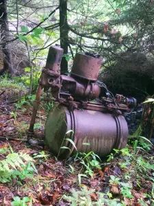
Throughout the area other curious odds and ends can be found, including entire vehicles abandoned in what are now remote places, but which were once active forestry roads. Some of these machines are clearly pieces of logging equipment, and some are items associated with rustic hunting camps that once stood nearby. These items are scattered far enough apart that they add to the personality of the area, rather than giving it the appearance of an overgrown junkyard.
-
It is no exaggeration to say recreational use of the Little Moose Wilderness is light.
The only officially-maintained trail fully within the wilderness is the 8.1-mile-long foot trail to Sly Pond. This route follows a sequence of abandoned tote roads on its long ascent of Little Moose Mountain, but the long distance and the absence of good camping options near the destination seem adequate to convince most people to hike elsewhere.
Otherwise the only other trails of note are the Wilson Ridge and Otter Brook routes, which together comprise a non-wilderness “wild forest corridor” dividing the Little Moose Wilderness from the West Canada Lake Wilderness. Its presence can be considered nothing less than poor planning on the part of the APA staff members who conceived it; envisioning a through-route for mountain biking, this trail is far too remote (not to mention linear and long) to appeal to most mountain bikers. Several miles in the middle sections of the trail are not maintained, and limited biking only occurs at the two ends of the trail.
Hunting is highly popular in the Moose River Plains region in general, and some of that activity does occur within the Little Moose Wilderness – though this, too, must be considered especially light. Evidence of a few “deer camps” can be found at scattered, seemingly random locations.
Despite the presence of a massive twin-summited mountain, Little Moose and Manbury are climbed infrequently due to their remoteness. The primary appeal is that Little Moose Mountain is counted among the so-called “hundred highest” Adirondack peaks, thus giving some bushwhackers an artificial motivation to toil over the long miles to the summit.
Campsites are rare to non-existent, although opportunities for at-large camping (at least 150 feet from the nearest trail, road, or water source) can be found at the more moderate elevations. By far, most camping occurs at the highly popular roadside sites along the Moose River Plains road system; a few of these sites are located just a few hundred feet outside the wilderness boundaries.
Because the only way to access the Little Moose Wilderness is via the seasonal roads in the Moose River Plains, the entire area is completely inaccessible to most people from December through May – unless you are willing and able to drive a snowmobile to one of the remote trailheads to begin your wilderness adventure!
-
One of the benefits of being a wilderness so unknown to most people is that Little Moose faces few threats. However, the biggest concern from a wilderness advocacy perspective lies with the so-called “wild forest corridor” that divides Little Moose from the neighboring West Canada Lake Wilderness.
“Wild forest” refers to the one of the other main Adirondack land classifications, similar to “wilderness” except these areas are far more permissive to motorized and mechanized forms of access – thus the Moose River Plains Wild Forest with its extensive road network and drive-in campsites, compared to the adjacent West Canada Lake Wilderness, which has no roads and can only be accessed by foot. As originally conceived by a state commission in 1970, the wild forests were the “yin” to the wilderness “yang,” roughly equal in size and evenly distributed, so that the proponents of mechanized recreation as well as the primitive forms could each have their fair shares.
However, the “wild forest corridor” here, which extends from Otter Brook on the west to Wilson Ridge on the east, amounts to a spot-zoned bike trail routed through a place that is otherwise dedicated to the wilderness values of foot access and primitive recreation. This is dumb planning, placing a non-wilderness facility where the people who might enjoy it are hard-pressed to find it, and where the social qualities of the landscape do not support its maintenance and upkeep.
The ideal solution is to abolish the corridor and add all 12,201 acres of the Little Moose Wilderness to the West Canada Lake Wilderness; suitable biking opportunities are already being planned elsewhere in the Moose River Plains Wild Forest. In the meantime, it is heartening to see that no effort has been made since 2010 to open the full trail, much of which exists in a de facto state of abandonment despite its official status.
-
The following links leave the AWA website and take you to various pages on the Department of Environmental Conservation (DEC) website with more information on the Little Moose Wilderness.
Moose River Plains Complex Information Page. Learn important contact information and peruse a list of facilities.
Backcountry Information for the West Central Adirondacks. Trail conditions updated weekly for the Moose River Plains Complex and neighboring areas.
State Land Regulations. Review the complete list of DEC regulations.
Maps of the Little Moose Wilderness and the Surrounding Area
Below is the current DEC map of the wilderness and its facilities. The remaining maps show the evolution of the area. Click maps to enlarge.
Moose River Plains and Little Moose Wilderness Map
West Canada Lake Wilderness Map
1903 West Canada Lakes USGS Quad
1954 West Canada Lakes USGS Quad
Little Moose Wilderness Image Gallery