When I began to explore the Adirondack Forest Preserve as a young adult in the 1990s, the Wilderness and Wild Forest areas had already been established two decades before my arrival. Furthermore, the discussion of which activities and which facilities should be permitted in each state land category had occurred several years before I was born. I never had any say in how the State Land Master Plan was developed; for the first twenty-one years of my life I had no clue it even existed.
But when I finally did discover the remotest recesses of the Adirondack Park, it felt like an epiphany: a light switch had been flipped on, and a part of myself I had not previously known (but always suspected) was now illuminated. Wilderness travel was immediately agreeable to me. It was an immersive experience that engaged my mind and challenged my body; the slow pace and rough edges existed in direct contrast to everyday life, a tonic to suburban normalcy. “Wilderness” was not an abstract concept after all, but a tangible reality into which I could disappear for two days every week.
And from the beginning I was keenly aware that the existence of all this Wilderness so close to my home was no accident. I was a beneficiary of the hard-won battles fought by wilderness advocates many years before me. I suspected that when those people had spoken of preserving open spaces for future generations, it was someone like me they had had in mind.
Before long I became committed to doing my part to carry this tradition of wilderness preservation forward. Therefore it was only natural that I would become a founding member, along with Pete Nelson and Brendan Wiltse, of a group called Adirondack Wilderness Advocates, which we conceived in May as a vehicle for promoting the knowledge and expansion of the park’s wildest places. This new entity is perhaps best described as an ad hoc committee at the moment, focused on the goal of seeing a strong Wilderness classification applied to the Boreas Ponds Tract, but who knows what it could become in the future?
The late preservationist Paul Schaefer was spurred into action half a century ago by proposals to dam the South Branch Moose River at Higley and Panther mountains, either of which would have turned a remote forest into a pointless reservoir. As I recall the story, one of the projects was more or less a done deal when Schaefer became involved. Nevertheless, he poured much of his time and energy into a movement to prevent the dam from being built—not only prevailing against steep political odds, but seeing the effort through to a constitutional amendment several years later, effectively removing the possibility of future flood control dams being built in the Forest Preserve.
Today, my generation has Gulf Brook Road as its rallying cry. It may seem like cheap hyperbole (sprinkled with a dose of narcissism) to compare the current situation at Boreas Ponds to the heroic efforts of Paul Schaefer, but consider this: before we formed Adirondack Wilderness Advocates this summer no one was seriously discussing a true wilderness proposal for this tract, one that saw the ponds as a remote destination rather than the setting for a trailhead. Even the major green groups were pushing for road access and snowmobile trails to the ponds, all as part of an up-front compromise package intended to please as many parties as possible. It was as if the wilderness community had aged and become more technology-dependent in recent years, and less concerned about the preservation of remoteness as it had been in the past.
Given the recent experiences with the Essex Chain acquisition, in which spot zoning and floatplane-only campsites were key parts of the final outcome, a wilderness classification at Boreas seemed doubtful. We appeared to be on a trend away from wilderness preservation in the Adirondacks, moving instead toward the increased mechanization of the outdoors.
But then the Boreas Ponds Tract opened to the public this past spring, and something odd happened: the gate at the beginning of Gulf Brook Road remained closed for several months. I visited Boreas Ponds the weekend of July Fourth and trailhead parking was at a premium, despite the long walking distance to the ponds. And when the gate to the road later opened in time for Labor Day, the new parking area fell far short of what the older groups had been calling for—ironically causing some Forest Preserve advocates to express their dismay that the road had not been opened far enough into the backcountry.
Pete, Brendan, and I formed Adirondack Wilderness Advocates in part to reclaim the wilderness narrative, which is at risk of being lost in discussions about trailhead parking lots and the preferred length of canoe carries. We’ve gotten so hung up on the details that we’re losing sight of the bigger picture. It’s time to reset the conversation.
Wilderness Until Proven Otherwise
I was reminded recently of the memo issued by outgoing Adirondack Park Agency member Richard Booth earlier this summer. “The SLMP creates a very strong presumption in favor of a Wilderness, Primitive, or Canoe classification for any new, large-acreage Forest Preserve acquisition that contains special resource values,” he wrote. “That presumption is especially strong for large newly acquired tracts that contain significant water resources.”
He was, of course, speaking in anticipation of the upcoming classification of the Boreas Ponds Tract. Hearings are already being scheduled for later this fall; the outcome will determine the long-term management guidelines for not only this acquisition, but also a host of others across the Adirondack Park.
The generation that created the APA and authored the SLMP more than forty years ago envisioned an apolitical classification process in which newly acquired state lands would be analyzed and assessed based on their physical and biological merits. “If there is a unifying theme to the classification system,” the original 1972 edition of the SLMP stated, “it is that the protection and preservation of the natural resources of the state lands within the Park should be paramount.” Human recreation was a secondary priority, one that “should be permitted and encouraged, so long as the resources … are not degraded.”
The SLMP never intended that the entire Forest Preserve should become Wilderness, but it certainly did identify Wilderness as the highest level of protection that could be afforded to any section of state land. What exactly was being protected? Most lands above 2500 feet in elevation, low-lying swamps and marshes, as well as rivers and lakes—specifically, those places not suited to handle large volumes of people.
The master plan also identified intangible or “psychological” aspects that needed to be protected, such as the sense of remoteness and solitude found in the areas that were far from motor vehicle roads. Like the flora on an alpine summit, these traits could be easily lost by mismanagement and poor planning. Prior to the creation of the SLMP there was no guidance on the location of access roads, jeep trails, and snowmobile trails, for instance. The old Conservation Department had been in the habit of allowing motorized access in the Forest Preserve just about anywhere, without thought as to how these developments impacted the perceived wildness of the backcountry.
The SLMP did not ban motorized recreation outright, but it did introduce the concept that motors were appropriate in some places and highly intrusive in others. The people with a heavy dependence on motor vehicles had far different expectations of what an outdoor experience should be compared to those who preferred to travel by foot. The SLMP attempted to resolve this inherent conflict by segregating the two forms of access into their respective land classifications.
The original SLMP did not try to comingle these competing interests with artful spot zoning techniques. Nor did it split hairs on how far any one truck trail or forest access road could extend before it threatened the integrity of the surrounding wilderness. Either the road conformed to its assigned land classification, or it did not. It was truly that simple.
This explains why I have been so disappointed with the quality of the discussion about Gulf Brook Road so far. For some reason it has been limited to an analysis of how well it will serve as a canoe carry. The term “reasonable access” has been bandied about more than once by the advocacy groups who want to see most of the road opened to motor vehicles. “Reasonable access” in this context is code for a paddler’s parking area, which some people want to see located at a strategic point close enough that a retired paddler might reach Boreas Ponds without much difficulty, but far enough away to keep some sense of seclusion once they get there.
As far as many people are concerned, this is all that the upcoming classification will be about: where to put the parking lot. But I find the hypocrisy behind this argument intolerable, because the underlying conceit behind “reasonable access” is that motorized access is good when it lets in the “right” kind of people—in this case, paddlers—but is bad when it lets in too many of the “wrong” people, the ones who might hoot and holler and destroy the illusion that Boreas Ponds is a remote and secluded place. In other words, motorized access is wonderful when it benefits you, but it is an obscenity to be litigated when it benefits the other guy more.
Limiting the discussion on how these new state lands should be managed to only its impact on canoe access can cause people to have an overly simplistic view of what is at stake. What should be a rational, policy-driven planning decision has been reduced to what I call the “Goldilocks Narrative”: either the portage (rhymes with porridge) will be too long, too short, or just right. This turns people like me into another fairy tale character. Whenever I bring up the proposal to close the entire road to motor vehicles, what people see in their minds is the Big Bad Wilderness Advocate huffing, puffing, and threatening to blow their canoe carry into a seven-mile slog.
But gauging the proper length of a canoe carry is not what state planning is about, fundamentally. One of the intents of the SLMP is to preserve as much Wilderness in the Adirondacks as possible, in all the places where it exists or can be restored. In his 2016 memo, Mr. Booth wrote:
…the general purposes of the Master Plan … suggest strongly what the Agency should generally do when large acreages of newly acquired Forest Preserve lands are classified: i.e., wherever possible those lands with special resource values should be classified as Wilderness; AND when that is not possible, those lands should be classified as Primitive or Canoe; AND only when that is clearly shown not to be possible, should those lands be classified as Wild Forest.
If you subscribe to this interpretation of the SLMP’s mandate, then any large tract of newly acquired Forest Preserve should be regarded as Wilderness until proven otherwise. That is to say, rather than wilderness advocates such as myself making the case for why Boreas Ponds should be protected, the burden of proof should fall on the other team. The people who would prefer to see access roads and snowmobile trails should be the ones demonstrating why this tract fails to meet certain criteria and cannot be classified Wilderness: it is bisected by a permanent public highway; the tract is a checkerboard of private inholdings; there is a wollastonite mine that is required to sustain local employment; Boreas Ponds must be a Wild Forest.
But if the tract has none of these disqualifying features, then the bias for classification must be Wilderness, because that is the only outcome that will satisfy the resource preservation goals written into the SLMP.
What Exactly Are We Protecting?
Does Gulf Brook Road serve a practical function that requires it to be retained indefinitely, for reasons that are beyond DEC’s control? In this case, no, there will be no special use reservations once the hunting leases expire. Does the road exist in a “frontcountry” setting, close to a large community, where it might be helpful in dispersing large volumes of people? Or is it an intrusion with a quantifiable impact on a sensitive resource, and therefore must be closed? It cannot be these last two things simultaneously, and I see no validity in the argument that the ponds can be Wilderness and the road Wild Forest, thus splitting the difference. Despite what we’ve been told, it doesn’t work that way.
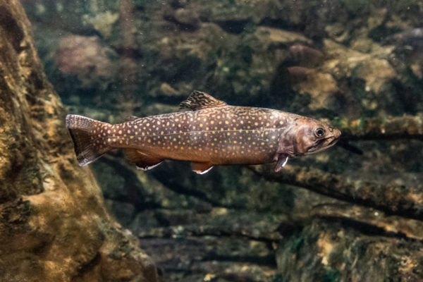
If you are advocating that Boreas Ponds should be protected as Wilderness, then what you are implying is that this waterway is a sensitive resource that might suffer from the impacts of large numbers of people. The fishery might decline, the shoreline might get trampled, people might start cutting live trees for the lack of available firewood. These are the types of impacts that the Wilderness classification was intended to mitigate, and does mitigate in most cases except the High Peaks.
This protection is achieved by banning mechanical forms of access; if it takes a little more time and effort to get someplace, then human visitation is likely to be lighter, a little more dispersed. Going there takes more thought and planning, especially when the destination is remote.
But when you intentionally place a public parking area in close proximity to the center of a wild area, you are undermining that protection. In the case of Boreas Ponds, all that you would really be accomplishing by placing your trailhead somewhere near LaBier Flow is a ban on motorboats. The merit of your Wilderness designation becomes little more than a ploy to enhance your paddling experience—i.e., if there are no outboards present it will be easier for you to focus on the loons.
Ironically, if this is your minimal goal, you do not need a Wilderness designation to achieve it. Let’s assume for a moment that the entire Boreas Ponds Tract was designated Wild Forest. Bikes are in, and you can drive as close to the water was you want. Even so, the SLMP explicitly forecloses the option of opening boat ramps for one basic reason: facilities for trailered boats are only allowed on lakes greater than 1000 acres in size. At a mere 320 acres, Boreas Ponds is much too small. The worst that DEC could do is install a fishing access site, at which people could only launch what they’re willing to carry down a short access path.
So it comes down to a question of what exactly it is that we want to protect, now that we are facing the decision of how to classify this new property. Are we most interested in establishing a multi-use recreation area based on a network of former logging roads? We already did that over at the Essex Chain, to mixed reviews. What about the terrific paddling opportunities at LaBier Flow and Boreas Ponds? Response: How is this opportunity any more special than the existing ones at nearby Elk Lake, Sanford Lake, Henderson Lake, Cheney Pond, and County Line Flow? It seems to me like we already have the paddling opportunities covered in this part of the Adirondacks.
My question is why are we assuming that this acquisition should be managed as a paddling destination? Boreas Ponds is an isolated body of water with no connecting paddle routes of merit. LaBier Flow is miniscule, only a fraction of the Boreas River is navigable, and so in this regard I’d say that the paddling options here are interesting, but very limited. Certainly, Boreas Ponds fails to meet the SLMP criteria for a Canoe Area designation, for the simple reason that you would not apply such a classification to a single pond. We can also rule out a Primitive Area designation, since there will be no non-conforming uses beyond anyone’s control after the lease camps are removed in 2018.
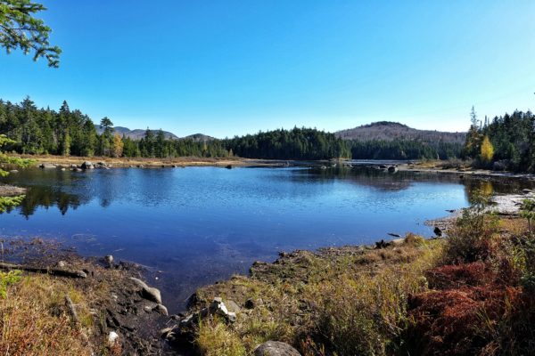
Boreas Ponds is essentially a large wetland, with marshy shores and broad patches of dead timber. If it were not for the views of the High Peaks, public interest in exploring this place by canoe would be much less enthusiastic. The physical reality is that this is a 320-acre flow located at the heart of 20,758 acres of forest. It is not the next Lake Lila; there are no sand beaches, there is no Shingle Shanty Brook or Frederica Mountain, and there are only a handful of camping opportunities.
This is not to say that paddling Boreas would not be rewarding—I am looking forward to trying it soon myself—but in this age of wheeled pushcarts and carbon fiber hulls, the difficulties of portaging a canoe along the entire length of Gulf Brook Road have been grossly exaggerated. And if portaging a canoe over this distance is not for everyone, then so what? Is a remote wilderness pond any less enjoyable if all you do is hike to its shoreline and enjoy its tranquility from land?
The Appeal of Remoteness
Therefore compromising the wilderness values of the entire tract for the sake of this one destination would be the epitome of poor planning. Every mile of Gulf Brook Road that remains open to motor vehicles reduces the remoteness of Boreas Ponds, as well as its level of protection. Mechanical access reduces not only the size of the protected area, but also the quality of the wilderness experience once you get there. The further the road penetrates, the further one would have to travel into the backcountry to escape its influence.

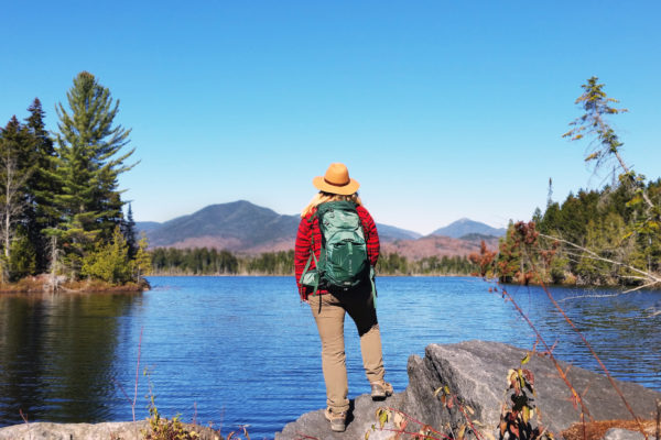
If the road never existed, Boreas Ponds would be among the remotest places in the Adirondacks. Think along the lines of the Cold River or the West Canada Lakes, two of the remotest places in the Adirondack Park. Rather than places devoid of people, these are destinations that are revered among backpackers. Humans are a curious species. Activities in which we invest personal effort—whether it be something that we create with our hands or a place that we reach with our own two feet—affect us far more personally than any passive experience ever has. We are at our best when we rise up to meet a challenge and overcome it. Exerting effort to get someplace is an accomplishment, in a way that driving a car will never be.
There are roads throughout the Adirondacks, ranging from public highways to seasonal forest access roads, and the vast majority of the Forest Preserve is no more than three miles from at least one of these corridors. This is a vast wealth of recreational opportunity for the people who cannot travel long distances on foot, or do not want to.
Remoteness is a much rarer resource in this technological age, and in this crowded part of the continent. It does not exist in the Finger Lakes, for instance, or out on Long Island; it’s not even easy to find in the Catskills, not on this scale. If we cannot summon the will to preserve it at a place like Boreas Ponds, then our commitment to wilderness preservation in the Adirondacks is truly waning.

The other risk with opening the gate on Gulf Brook Road comes not with paddlers, but with peak baggers seeking new routes into the mountains. If you draw a circle with an eight-mile radius around the summit of Mount Marcy, you will find within that range the trailheads at Heart Lake, Elk Lake, and Tahawus. The Heart Lake trailhead has become so busy that DEC announced it will be actively turning away latecomers this fall, once the parking area is filled to capacity.
You will also notice that Boreas Ponds and LaBier Flow fall within this same circle. It is therefore reasonable to conjecture that once people discover the connections with the trail to Panther Gorge, these ponds could face the same problems currently seen at Marcy Dam and Lake Colden. Remember, the closer the parking area is to Boreas Ponds, the closer it will also be to the High Peaks. People coming for a Sunday afternoon paddle might find it difficult to find a place to park, and they too might be turned away.
Doing More than the Minimum
Gulf Brook Road will serve no utilitarian purpose once all of the remaining exclusive leases come to an end in 2018. If it is left open to automobiles, snowmobiles, and other forms of mechanized transport it will be an intrusion into the largest new Wilderness candidate that we’re likely to see in a while.
This is not a discussion about “manufacturing” wilderness as some critics might say. I have walked this tract several times, and while it was certainly logged and otherwise modified by human activities, it was hardly raped. This is more about restoring wilderness conditions to the land after a century of private ownership. Most of the forest seems to be in very good condition, a few recent cuts notwithstanding. Even with the hunting club leases, human use of the land has been light as far as I can tell, mostly limited to the areas near the camps. The road will grow in over time—a process that would occur faster if we ripped up the gravel surface first. Culverts should be removed to make the streams friendlier to fish movement.
The specter of motorized access is a looming and immediate threat to the wild and remote character of the land, however. It is a threat that should be vigorously opposed, because in my opinion it is one that can be defeated. DEC has already handed us an interim management plan that is several degrees wilder than what the larger advocacy groups had lobbied for. To me, this says that the door is open, that Wilderness is an option. What we need to do now is muster the collective will to make it happen.
The long-term management plan for Boreas Ponds should not be about preserving the minimum—doing the least we can do lest some segment of the population becomes offended. If we feel strongly that the remoteness and quiet beauty of the Boreas Ponds Tract is a precious asset that should be preserved for the benefit of current and future generations, then let’s make the strongest effort that we can put forth. Let’s move the wilderness narrative forward, not backward.