
Old Roads on Old Maps

We are on the south side of the stream, and there is no sign of the old logging road. All around us are open hardwoods: mature maples and birches arching over a forest floor carpeted with a thin layer of snow—a layer that is barely sufficient to cover the lycopodiums, their evergreen tips poking upward like fresh spring shoots. There are no marks in the trees, no indication that the earth was ever disturbed. If the road were located here it could be impossible to make out in this open space.
Nearby is a pocket of spruce, an elongated little swamp-forest at the source of Groff Creek, embedded like a gizzard in the heart of the hardwoods. If we were to continue any further through this valley we’d be in the next watershed. The creek at this point is little more than a gelid channel of black water worming its way through the woods, with no indication of the minor force it will become before spilling into the Sacandaga River just a few miles away.
It has been quite a while now since we last saw an obvious part of the old roadway, and ever since then it has been like we’re looking for a ghost. I know it’s here, because it shows so prominently on the old USGS map I have at home. I wish I had it with me here, but of course it wouldn’t help the longevity of a sixty-three-year-old map to carry it through the backcountry. But I wish I had made a photocopy, because at least then I would’ve had a better idea what side of the valley to be on.
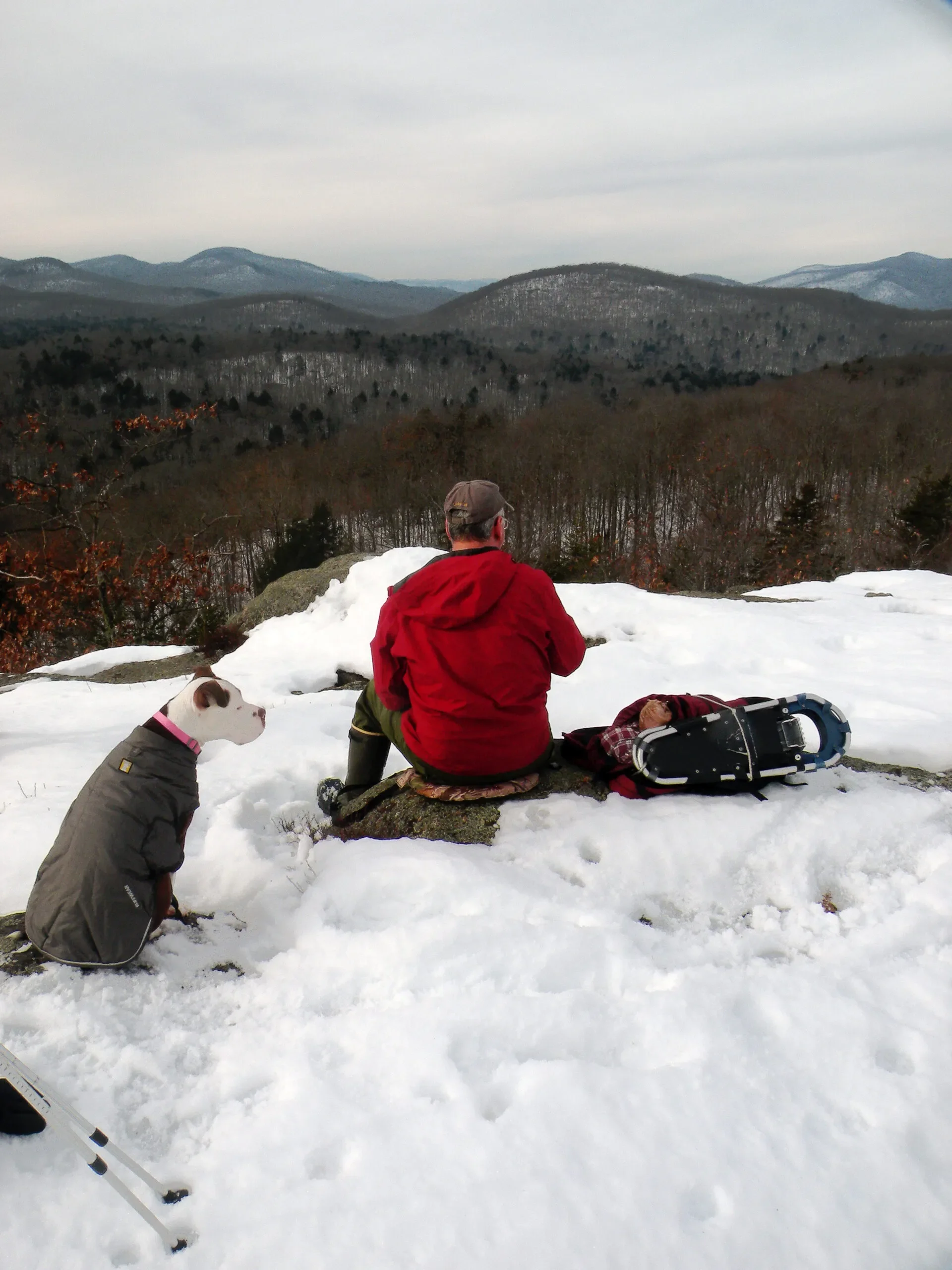
My dog Purdy is enjoying the slow pace I have been setting, and she has been following me all day on my meandering course without complaint. She is only unhappy when we stop, because despite the lackluster snowfall it is January, after all, and it is cold. Her patience today has been a big help, and she has been expressing no doubts or reservations as I’ve abruptly changed course from one turn to another.
Wherever that road is, I have no reason to believe we’re standing on it. By the same token, I have no reason to believe we’re not standing on it, either. I just know this one basic fact: it shows on the old 1907 Lake Pleasant topographic quadrangle (surveyed in 1904 and reprinted in 1939) as a very prominent route leading up along Groff Creek to a camp at Devorse Creek. It passed right through this valley—if not within inches of where we’re standing then within yards—and I can’t detect a single trace of it.
Maybe we should look to the north of the creek. Groff is so narrow here that it takes only a step to get across; for Purdy it is more of a hop. There is certainly no indication of anything in the dark little spruce stand, and I can’t imagine any road builder cutting a route though such a boggy spot. The patches of sphagnum are frosty and hard today, but we nevertheless can feel the give underneath us as we step through.
The spruce has a very limited reach, and soon we’re back in the hardwoods. The terrain rises in no particular rush to form a gentle hillside, which according to the modern topographic map I carry in my hand is a neighbor of King Vly Mountain. This particular hill is not distinct enough to bear a name of its own, and it mirrors the anonymous hillside we saw moments ago on the other side of the stream.
I have only one hope for this hill. I know from past experience following these nineteenth-century routes that when the builders encountered a hill, they often banked the road grade into its side to maintain a level surface. Even if the road has not been maintained for decades for any reason, even as a footpath, these minor earthworks remain obvious no matter how many trees now fill it in. This is what I scan the ground for now: an indication, no matter how subtle, that someone once modified the terrain to ease the passage of wagons and sleighs.
The metric map that I carry today is sobering: it shows exactly what we have already found and promises nothing else. As of 1990, the date on the title pane, the USGS is asserting that a trail extends from the Sacandaga River up into the valley of Groff Creek and ends near a vly on a small tributary, as represented by a thin, dashed line. The map was uncannily accurate in this respect, as if federal agents had actually been here to confirm the old road now ended at this spot and the rest could be erased from their records.
However, this same metric map also shows a similar trail from Upper Benson ending at the Notch between Wallace and Three Ponds mountains, just a few miles from here. Purdy and I hiked this route last summer when we backpacked into the Devorse Creek valley, and we found this depiction to be only partially correct. That trail also had its origin as a primitive logging road, and it was true that the modern footpath ended at the Notch. But that was just where whoever is clearing the route put away their saws and ceased doing any further maintenance; it was not where the original road ended. As the two of us had continued toward Devorse Creek we found long portions of the remaining road where it had been benched into the sides of hills. It made no difference that enormous yellow birch and ash trees now encroached upon it and fell dead across it, because even this small amount of earth moving had left an indelible mark on the landscape. It was only where the route had ventured onto the wide-open valley floor that it now melded into perfect obscurity, completely reclaimed by the maturing forest.
My older map—a Depression-era reprint that someone once bought from the Watford Drug Company in Utica for fifteen cents—shows that the Benson Township was crisscrossed by an elaborate network of trails and logging roads by the close of the nineteenth century. According to the legend, the area was surveyed twelve years after the founding of the Adirondack Park, meaning that the roads it portrays are very old. All of this is now state land, and in fact most of it already was state land before the map was first published. Between the end of that survey and our visit today, the entire twentieth century has passed as a time for natural regeneration and recovery.

Snowshoers near Rock Lake
Those road segments that we found last summer—some along the upper reaches of Devorse Creek and another beside Jack Green Creek—were delineated on that old map by single dashed lines. This route along Groff Creek was depicted with a double dashed line, implying that it was a more significant road than the others. They had all converged at Devorse Creek, where the map clearly indicated there had been a camp. We had found the trees at that spot to be strikingly curved and rather small, telling me that they had grown in what had once been an open clearing. In the bed of the creek were the base logs of some kind of dam. Structurally, nothing remained of that dam, but a tiny vly immediately upstream had clearly once been a pond for however brief a time.
That double-dashed road along Groff Creek must have once been the main supply route to that dam and camp, so why couldn’t we find any trace of it now?
We are walking particularly slowly now, and I am aware that if I keep us dawdling too long Purdy will whimper with impatience. She likes to hike but she has no love for the cold. I am looking at a peculiar space through the trees. It does seem to be a straight cut through the hardwoods, albeit a slight one. The gray trees have for whatever reason avoided growing in this one swath, leaving an empty space that is the closest thing to a road that we have seen in more than two hours. There is no ground disturbance. There are no cut logs. There are no ribbons tied to any trees that I can see. There is no positive evidence of any kind that we are standing on a man-made pathway. There is simply an absence of trees that somewhat resembles the footprint of a road.
For a while today, I had wondered if I wasn’t the only person who had come to Groff Creek in the first days of this new year. Coming up from the river, we had followed a set of boot prints flanked by two sets of dog tracks. There was only the one set of tracks heading into the woods, so my initial reaction was dismay: were we really going to have to share these woods with someone else? Would Purdy be okay with the other dogs? She spends so much time with people that I think she has forgotten she is a dog herself, and she sometimes gets nervous around others.
Then we found the outgoing tracks, which had split off the trail to find a new way home. The boot prints were remarkably small, so this other person was likely a woman. She and her two companions, I realized, were fellow rovers, utilizing the trail but in no way feeling constrained by it. Their day in the woods had passed and now this lonely valley was entirely ours.
The trail continued past a bend in Groff Creek to a large vly, where the beavers of old had built several large dams and managed to flood out quite a chunk of the birch-and-hemlock forest. This was where the road—so very clear and well cared for up to this point—curiously faded away. If I recalled the old map correctly, the original road somehow curved to the northwest to rejoin the main creek at this point. Perhaps the next portion had been flooded? Beavers were all but extirpated from the Adirondacks at the time the road was built, so even if this vly existed back then the potential for routine flooding did not. The road builders would not have been too shy about cutting through this low area, if they had no other choice.
The woman and the dogs had crossed the mouth of the vly on a long and sinuous dam, and we did the same. The thing was so old that brush grew thickly on it and weeds naturalized its steep slopes. The vly maintained a tenuous boundary with the surrounding forest, with stumps and logs extending into the frozen pond and with snags where the pond was extending into the woods. The final shape of the pond had not yet been determined, and neither side was claiming a clear victory or defeat.
Was she looking for the continuing road, too? If so, she never found it. What she did find, as did we, were countless deer tracks. There was a hemlock stand at the far end of that beaver dam, and a small herd of deer had spent a night here very recently. We could see where each body had been curled up, leaving a mark in the thin snow cover. Her tracks crossed and re-crossed those of the deer, and ours crossed hers.
But whatever she had come in search of, she had found it near the vly. The boot prints and paw prints did not venture far beyond the reach of the hemlock stand, whereas the tracks we left continued on a determined course deeper into the recesses of the valley.
We follow the gap in the woods—the linear opening that might be a trace of the road, or that might be nothing at all—westward and further into the woods, hoping to be led back to that dam site on Devorse Creek. Purdy and I must be near the point where the Groff Creek drainage comes to an end and all further streams will be flowing down toward Devorse. The map that I carry suggests there will be no clear dividing point, no little hill to straddle with one tributary flowing one way and a second stream flowing the other. The valley is long and drawn out, and ultimately the far end will simply drop away in the opposite direction. I wouldn’t be surprised if the spruce swamp beside us turns out to have two outlets, discharging water in both directions.
But within just a few steps, the slight sense of success that I felt a moment ago gives way to a series of deadfalls. What I expected to be the course of the trail is obstructed by the felled bodies of several trees, some of the older ones blackened by rot and decay, all of them capped by a thin coating of snow. It is not that the trees have fallen across the trail—it looks from this point forward like there never was a trail or a road or anything man-made here at all. Ever. One by one, the old hardwoods have been brought down by age and winter winds across our intended route, and the woods that we are facing into are as wild and trailless as anything we’ve seen all day.
Under other circumstances it would not be that difficult to bypass the deadfalls and simply bushwhack the remaining distance into the next valley, but I am getting discouraged. I seem to be looking for an artifact that doesn’t want to be found. The afternoon is wearing on, and our limited supply of daylight will fail us in a few hours. Yes, we could continue to Devorse Creek, but then we would have to make our way back—let’s say another hour to reach the creek; and once we get there I will want to look around of course, so there’s another thirty minutes; and then another hour just to get back to this spot. Plus however long it will take to return to Groff Creek and hike out along the trail. There comes a point on these types of trips when you must readjust your expectations. In our case, we have been searching too long for something with too few results, and my preoccupation with the route has put our destination out of reach.
Town Line Ridge
Okay, so today is not our day to return to Devorse Creek and it is now time to begin heading back—but I see no reason to hurry through the turning process. This is as good an opportunity as ever to pause and take a drink of water. While I reach into my pack, Purdy sits her hind end uneasily on the ground; it is a comfort to take a break from hiking, I’m sure, but somewhat less so for her when she’s sitting on snow. Really, as the crow flies, we may be well within a mile from the cabin site. I had come here convinced that there would be some sign of that road, even if all that remained was a forgotten and overgrown track. It’s hard to accept that nature has erased it so completely. A footpath, yes, those things can vanish in just a few seasons. But a road? To Purdy, this U-turn we are about to make will be little more than the latest in a series of directional changes, but to me it will be a mild disappointment.
In a moment, though, once my canteen has been put away and we are ready to get moving again, we return to that curious gap in the forest, the one that I had gotten excited about; and upon a second examination it does still look vaguely like a road. This is heartening, but it’s difficult sometimes to distinguish between imagination and observation, what I want to see versus what my senses are actually reporting. There is enough of a continuous space that I am convinced that we have found a vestige of the logging road, as subtle as it may be. And I am equally convinced that this could just be a natural fluke, a coincidence of seed placement and tree growth that has resulted in a road-like passage.
Whatever it is, we are now following it eastward back toward Groff Creek. This “row of emptiness”—let’s call it that for now—is curving at the same gentle turn ratio that a road would make, and it is maintaining an almost constant width, even if the ground surface blends harmoniously with the undisturbed ground in every other direction. It looks like it could be the road, and yet it does not at the same time.
But perhaps for the first time since leaving the beaver meadow this morning we are walking at our fastest and most purposeful pace. If we had managed to do this earlier, we might have actually reached Devorse Creek today. It’s curious how having an established route to follow—or even just the appearance of one—can be so reassuring, despite all my habitual wandering. Without the ingrained, human tendency to follow in someone else’s steps, there would be no trails anywhere. We’d all be content to wander along our own independent tangents at our own carefree paces, rarely placing a foot in the same place as someone else. But whenever I step off a trail—whenever I act against that human tendency—my pace slows and I become far more careful and deliberate about where I step. There is nothing carefree about it.
For a few minutes our pace is brisk as we follow what could be the old logging road—until it comes to an abrupt end, and we are simply back in a forest where the trees are randomly placed and the ground is so lumpy and uneven that it seems unlikely that we are anywhere near the correct location. It is over as quickly as that.
The rock ledge is tilted back at an angle, about the same pitch as a steeply gabled roof. It is encrusted with ice, as is the battered log that stands against it. Pendulous icicles, wider at their bottom than their top, are suspended along the entire length of the log like an extended rack of bowling pins. Groff Creek is tumbling both over and under the crust into a rock-lined trench below. The ice is impeding the water’s fall today, but in the spring I suspect there must be quite a flow, the water not quite white but bearing an amber stain from all the tannins. It’s always hard to guess the height of these things, so I try to visualize what I’d look like if I could stand next to it. A second person could stand on my shoulders and there would still be several feet of rock above us. So let’s say this waterfall is fifteen feet tall. At least twelve.
We are standing on a lower ledge that stands opposite the cascade, with the trench-like formation between us—not only is this an attractive waterfall, but it comes with an awesome viewing perch, too. Surrounding us is one of the most beautiful hemlock stands imaginable, the purple-brown trunks supporting a heaven of deep green boughs. The trench is diverting the course of the creek away at a right angle from the base of the falls, and downstream I can see a long, straight cut through the thick woods. At the far end of that run, perhaps sixty feet away, the creek veers right to spill out of the trench. If the entrance to the trench is a fifteen-foot waterfall, I’d like to see what that exit looks like.
What an unexpected discovery. The grade in this upper part of the valley is so gentle that I had no reason to suspect anything as dramatic as this was waiting for us. As we followed the creek back downstream—letting it be our guide through the valley after abandoning the search for the road—I had gotten excited when I saw it disappearing ahead of us as if over a ledge. In the springtime you can hear a waterfall from some distance away, but the sound of this one is muffled by the ice. It was only when we stood upon the top and saw the drop-off below us that I could be sure of what we had found.
Ice and Snow on the North Branch
By my guess we are getting very close to the beaver meadow again, and that means the trail—the one part of the old road that is still being used and maintained—is not far away, either. There are no footprints here except for our own, just the linear sets of hoof prints left by deer traveling between the creek and the vly. The woman and her two dogs never came this way, and the terrain is so uneven and rough that no nineteenth-century road builder would’ve come anywhere near this particular place. That doesn’t mean that some small, autonomous part of my consciousness isn’t still busy looking for it. I had perhaps been held in suspense for so long that some part of me is bound to keep looking out of habit. Every gap in the trees with any length to it is a potential segment, every shelf-like wrinkle in a hillside a potential dugway. The difference now is that I have stopped believing in these ghosts and shadows, and I have refrained from going in for closer examinations.
What exactly had I been expecting? If someone was really still using the far portions of the route and maintaining it as a pathway, then we would have picked it up early without much difficulty. I have become quite good at finding established paths, even the faint ones. We would have traced it all the way to its end, and we’d probably be working our way back along the exact same route at this minute—but by doing so, we would never have found this waterfall. That is perhaps the tradeoff with trails. With them you can often travel farther, but without them you often see more and discover more.
The USGS surveyors were savvy enough about the status of the road to correctly update their maps, but they made no mention of any waterfalls on Groff Creek on any of their editions, new or old. Maybe they knew of this spot but didn’t deem it worth reporting. If that’s the case then I disagree with their assessment. As far as I am concerned this is a landmark, a point of interest worth noting, and its omission makes the map I have been carrying all day—the metric Three Ponds Mountain Quadrangle, 1990 provisional edition—incomplete. With a pencil I draw a short line on my copy, a graphite hyphen across the blue line representing Groff Creek at what is to the best of my skills our precise location. Perhaps the map did not show the location of this waterfall before, but it does now.