Ampersand Mountain is a former fire tower summit that now stands guard over the northwestern corner of the High Peaks Wilderness. No tower is needed here for a view, because the bald rock knob that constitutes the summit provides an outstanding vista in all directions. To the north is the lake country of the Saranac and Saint Regis chains, and to the south and east is the mountainous wilderness interior. Few summits provide such good views of both.
The trail to Ampersand is best described as short and steep. The route follows the course of the original trail, a route that has been used for generations. It was created at a time when no one anticipated the long-term maintenance problems of erosion, or understood the best way to build a sustainable trail. It simply follows the most direct line to the summit and never flinches. Several years ago it was “modernized” with the installation of rock steps along many of the more problematic pitches, although it is not clear that these have been sufficient to end the erosion problem. Many hikers choose to hike beside the steps, and so the issue persists.
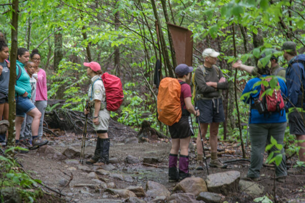
This is an immensely popular hike, and often the number of cars parked at the trailhead exceeds the capacity of the parking area. State land stewards are mulling options to relocate and enlarge the trailhead.
Getting There
The trailhead is a prominent feature on NY 3 between the villages of Tupper Lake and Saranac Lake. You will find it on the north side of the highway 8.3 miles west of downtown Saranac or 12.5 miles east of downtown Tupper. A short trail to Middle Saranac Lake begins at this same location.

The Trail
The trail to Ampersand Mountain begins across the highway. The steep climbing does not begin right away, and in fact the first 1.6 miles of the trail are very pleasant. The route crosses Dutton Brook while you are still within earshot of the highway and then shoots southeast through a lowland forest that is tall and mature. The trail is reasonably dry despite the high traffic volumes, and it leads through several peaceful stands of hemlocks. There are small streams to step across, a patch of old blowdown where new growth shades the mossy remains of the fallen trees, and a birch tree with all of its roots standing well above the ground—left exposed when an old stump rotted away. Basically, the first part of this trail is all about the sheer joy of being in a wilderness forest.
Slowly you begin to climb, with the trail pulling near a small, unnamed stream. At 1.6 miles, or about 40 minutes from the highway, you reach a tiny clearing with the remains of a metal bedframe beside the trail. This was the site of the observer’s cabin from the days when Ampersand’s fire tower was manned every spring, summer, and fall. The watchman who slept here climbed the mountain every day. Other than a handful of artifacts, little remains of that cabin today.
The trail angles south here and continues climbing gently, but soon it becomes obvious that you have reached the mountain proper and have embarked on the main ascent. There is no getting around the fact that the slope is steep and relentless.
The rock steps are helpful where they are present, but they are not a perfect solution. They were constructed with the narrow dimensions of the ideal foot trail, with the hopes that the peripheral areas would recover and fill with vegetation over time. That has not occurred though; the muddy conditions flanking the steps prove that many hikers are bypassing them and perpetuating the conditions they were intended to replace. Part of the problem is that the steps did not address the issue of stream flow down the mountain’s fall line; at times, they are a lively cascade of running water.
All that aside, don’t let the management issues with the trail detract too much from the hike. Your vertical progress up the mountain is marked by transitions in the forest cover, from the hemlocks and hardwoods at the foot of the mountain, which soon give way to spruce and paper birch on the mid slopes, followed by the balsam fir that crowns much of the summit. Along the way are a few rock ledges here and there that may require the use of your hands to pull yourself up.
The grade does not ease until you reach the multi-knobbed summit area at 2.3 miles, having just climbed over 1000 feet in the last 0.7 mile since the cabin site. The trail is briefly level as it swings left between two false summits, but then it climbs past an enormous rock that intrudes into the walking space and conceals a long slot that is just wide enough to walk into. You might start to think you’ve overshot the summit when the trail starts to lead downhill again, but it swings right and begins the final steep scramble to the summit.
The trees part abruptly to reveal the bald summit knob, which appears as an imposing ledge but soon becomes a scenic wonder once you reach the top. Yellow paint daubs on the rock lead the way across one high point with the most incredible views, then down and up to the flat area where the fire tower stood, 2.6 miles from the start. There is no shortage of room to stake out your space to sit and enjoy lunch.
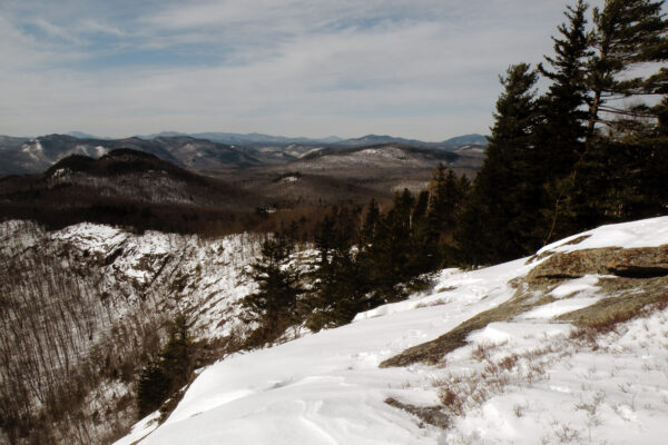
The view is outstanding! In one direction is the lake-studded expanse of Middle Saranac Lake, with Mount Arab rising above the distant buildings of Tupper Lake. There are lakes everywhere in that direction, as well as the scattered mid-sized mountains that characterize the northern Adirondacks. By turning 180° you have an equally enchanting view that includes the heart of the High Peaks Wilderness. Seward and Seymour are the nearest of those summits, just across the Ampersand Lake valley, but the view extends all the way to Algonquin some 12 miles away. Whiteface can be seen to the northeast, and a piece of Long Lake appears amidst the foothills to the southwest. Care must be taken on the steeper portions of the descent, especially if the rocks are wet or icy. Since the trail is located on the shady north side of the mountain, ice may very well linger here well into the spring, even after it has vanished from other locations.
