Recently I have been making a point of revisiting a few sites I briefly explored years ago, when I first became a guidebook writer. Back then, I was trying to see as many places in the Adirondack wilderness as I could within a limited amount of time, often not giving them my full attention. The Forest Preserve is filled with a seemingly endless list of fascinating destinations, and damned if I don’t want to know them all as well as old friends.
Tops on my must-revisit list was the 38,000-acre Hoffman Notch Wilderness near Schroon Lake, a region I am ashamed to admit I don’t know as well as I should. Sandwiched as it is between the High Peaks Wilderness to the north and the Pharaoh Lake Wilderness to the east, this area is easy to overlook. It possesses few landmarks that might qualify as “popular” outside of a small base of aficionados, and no superlative features that can compete with the charismatic draw of its neighboring regions.
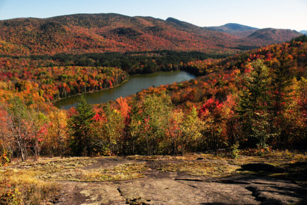
Nevertheless, Hoffman Notch is a noteworthy wilderness, occupying a niche between the high-elevation summits of the High Peaks and the dry, low-elevation slopes of the eastern Adirondacks. Thousands of people may drive past this wilderness every day as they travel the Adirondack Northway between Schroon Lake and North Hudson, but the wilderness itself is lightly trodden.
Among the places I have revisited are Bailey Pond and its close neighbor, Marion Pond. On maps they appear quite close together, and indeed they are – but these ponds are hardly twins. At about 1650 feet in elevation and less than a mile from the trailhead, Bailey Pond is a pine-rimmed pool bathed in sunlight. It is evocative of the numerous beaver ponds visible along the Northway, a place where winter never overstays its welcome.
Marion, on the other hand, is perched up in the adjacent hills at nearly 2300 feet – high enough to show an affinity for the central Adirondack highlands, with a shoreline of spruce, balsam, and maple. The snow here takes a little longer to melt, and the forest shadows seem more pervasive.
What a difference 650 feet in elevation make!
The experience of reaching each pond is vastly different too: Bailey is accessed by a wide and obvious trail, but Marion sits at the end of a faint path that many people will find hard to follow.
These are my impressions, at any rate, but perhaps you’ll want to see for yourself. Assuming you are up to Marion’s navigational challenges, the total hike is 2.7 miles one-way, with that 650-foot elevation gain. If you are just looking for something easy (and even family-friendly) then the 0.9-mile section to Bailey is more than worthwhile.
Getting There
The trailhead is located in Loch Muller, west of Schroon Lake. From Northway (I 87) Exit 28, drive south on US 9 through Schroon Lake Village to Hoffman Road, a right turn. At 6.2 miles you reach Loch Muller Road. Turn right and follow the road for 2.5 miles to the end of public maintenance, where snowplows turn around in the winter.
To reach the trailhead, continue into the woods on what is now essentially a driveway. It dips through a small glen and then swings right, reaching the tiny clearing that serves as a trailhead parking area. This final 0.2-mile drive can be a bit rough, with ruts that test the limits of low-clearance vehicles.

Bailey Pond
The hike to Bailey Pond is among the easiest trails in any Adirondack wilderness area, hampered only by the frequent muddiness that plagues most of the 0.9-mile hike.
Once you’ve found the Loch Muller trailhead described above, you’ll find no fewer than four DEC signs pointing the way to Hoffman Notch, the signature wilderness trail in this area. The signs pointing the way to Bailey were missing as of April 2021, but the trail is easy enough to find: just enter the woods and look left for the blue foot trail markers.
The first 0.2 mile is a bypass around private property, coming within a stone’s throw of someone’s rustic camp. Then at 0.2 mile the trail intersects an obvious woods road and turns right to follow it through a forest of poplar and red pine. This road couldn’t be easier to follow, although the bog bridging is not always adequate for the amount of muddiness you might encounter.
Not too many decades ago this road was still an active motor vehicle route leading to an inholding near the pond. Now the motors are gone, and at 0.9 mile the road comes to an unbridged crossing of the West Branch Trout Brook. The blue trail markers veer left here, leading the final few hundred feet to the outlet of Bailey Pond.
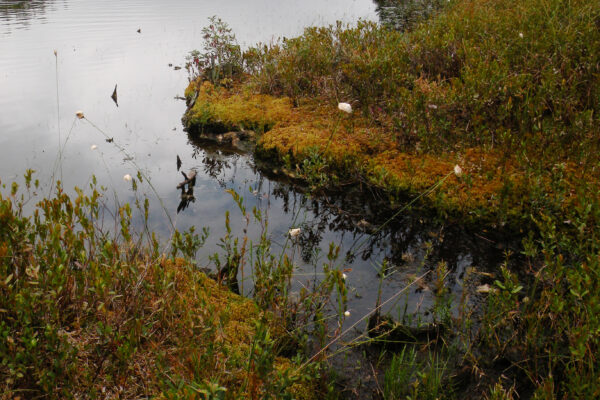
The spot where the trail ends next to an old stone dam seems like an obvious campsite, although technically the state recognizes no designated campsites in the Hoffman Notch Wilderness and has removed the fireplace that used to be here. If you are not planning to camp, then this hardly matters; this is an outstanding place to sit and contemplate the majesty of nature. Bailey’s shoreline is wide open, with plenty of rocks on which to sit and study the view up the shallow pond toward the steep slopes of Hayes Mountain.

Marion Pond
Marion Pond is less than a mile away in the hills above Bailey, but it requires far more effort to reach. The fisherman’s path leading to it has grown faint in the years since my first visit, and the route would be impossible to find were it not for the flagging used to informally mark the route.
The beginning is easy enough to find. Where the old road to Bailey Pond reaches the West Branch Trout Brook described above, the continuing roadway is clearly visible on the far bank even if no bridge currently exists. Except in times of high water you can easily cross the stream’s exposed rocks to follow the continuing road. It leads in another 0.4 mile to a second stream crossing – technically the same stream, although here it is called Bailey Pond Inlet.
Cross the stream and look for the continuing roadway, which remains obvious even if use is light and there are no trail markers. It leads north alongside Bailey Pond Inlet, but climbing slowly away from it through a hardwood forest. Just 0.5 mile from the last stream crossing (1.8 total miles from Loch Muller) the road reaches an area where a few man-made objects can be found in the woods, indicating the location of a long-gone camp. The obvious roadway ends here, and thus begins the flagged path.
By “flagging” I mean colored the colored plastic ribbons commonly used by sportsmen to mark an informal route. Their use is hardly legal in the strictest interpretation of state land use regulations, and I do not intend to comment on their desirability. Nevertheless, the continuing path to Marion Pond has grown so faint that it would be impossible to find without the flagging.
On the other hand, I’m not convinced the flagging I found in April 2021 is completely faithful to the historic trail, or that it represents the best possible route to the pond. The final 0.9-mile segment from the end of the road is excessively steep, always seeking the most direct way up the mountain when a more oblique angle would do far more nicely.
Another confusing element is the inaccuracy of topographic maps, which portray the trail as following the pond’s outlet. There is no outlet stream here, just a hardwood forest that becomes more spruce-filled as you reach top of the ridge.
The last leg of the path might be the hardest to find, but it leads southwest to a prominent campsite on Marion Pond. Be sure to follow the path to the shoreline, where you’ll find a garnet-studded rock ledge with outstanding views of this high-elevation pond.
