
My Start in Armchair Exploration
On days like today where it is 45 degrees and raining hard, I sometimes decide that “virtual” exploration sounds like more fun than the wet and cold kind. Not that experiencing such a day isn’t fun in some perverse way, but I find joy in the bookish kinds of exploration also. They don’t require a long trip in the car, logistics, and sometimes, for me, planning a trip or visualizing a place is just another way visiting a remote place.

Adirondack Mountain Club High Peaks Map, 1962 edition.
This is one of the first maps of the Adirondacks I ever owned. I marked the trails with red, yellow, and blue ink. At the time I didn’t realize that this was water soluble.
The map above illustrates one of my first adventures in exploring at home. The 12 year-old version of me carefully added in the colors of the trails using pens I bought for the purpose. This helped me visualize the trail network a little better and it also began the process of committing the place into memory.
Perhaps the first trip I planned with this map was an expedition to the Dix / Elk Lake region. Based on this map, I convinced a few people from my Boy Scout troop that we could ascend Nippletop before dinner. We camped at the Dix Pond lean to and the few foolish kids who decided to come along ascended the brook you see in the map below that appears to reach nearly to the the summit.
Needless to say, we had a late dinner that night, although the view from the top was simply spectacular (unfortunately there is no evidence from this trip to share). The brook did lead us in the right direction and it did go quite high up. It was STEEP though, and I learned for the first time about cripplebush.
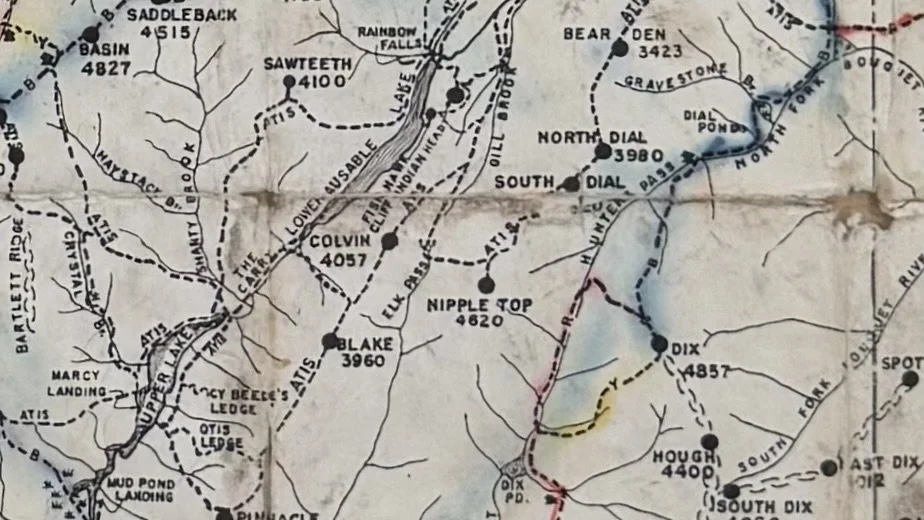
The hardest possible way to climb Nippletop is via the brook from the southeast.
Clearly, this was a lesson to be learned. In the mountains, if you can’t visualize the steepness, you are going to have a hard time.
I’m going to write a few short articles about how I’ve progressed since this early experience, which has lead me to learn how to make my own maps and use them for Wilderness Advocacy.
I’ve attached a clickable version of the map for anyone who wants to do some armchair exploration themselves.